


The Presidential Traverse: An Epic Endurance Day Hike in the White Mountains
- Stephen Warner
- Dec 26, 2023
- 11 min read
Updated: Apr 3, 2025

This grueling but stunning day hike—spanning eight of New Hampshire’s highest peaks—is a true test of endurance and willpower. Expect rough terrain, constant elevation changes, and unpredictable weather as you trek over 20 miles in a single day. But bag them all, and you’ll have completed one of New England’s most iconic adventures.
Trail Info
Trailhead Name | Presidential Traverse |
Distance | 21 miles / 34 km (point to point) |
Estimated time | 12+ hours |
Elevation gain | 9,000 ft / 2,750 m |
Highest point | 6,288 ft / 1,917 m (Mount Washington) |
Permits / fees | No |
Parking | North terminus: Off highway by Valley Way Trail South terminus: Off highway by AMC Highland Center |
Toilets? | At huts along trail |
Dog friendly? | Yes |
This trail which shows the route to Mount Jackson (optional)
Leg Info
Leg Name | Distance* | Elevation gain | Water stops** |
Valley Way to Madison | 3.8 mi /6.1 km | 4,000 ft / 1,360 m | Madison Hut (3.3 mi /5.3 km) |
Star Lake to Adams | 1 mi /1.6 km | 1,000 ft / 340 m | Madison Hut (0.5 mi/ 0.8 km) |
Gulfside to Jefferson | 2.1 mi /3.4 km | 800 ft / 270 m | None |
Gulfside to Washington | 3.1 mi / 5 km | 1,400 ft / 480 m | At summit (3.1 mi / 5 km) |
Crawford Path to Monroe | 1.5 mi / 2.4 km | 300 ft / 100 m | Lake of the Clouds (1.5 mi / 2.4 km) |
Crawford Path to Eisenhower | 2.2 mi / 3.5 km | 300 ft / 100m | None |
Crawford Path to Pierce | 2.6 mi / 4.2 km | 300 ft / 100m | None |
Webster-Jackson to Jackson | 2 mi / 3.2 km | 400 ft / 135 m | Mizpah Hut (0.5 mi / 0.8 km) |
Webster-Jackson to finish | 2.5 mi / 4 km | - | The first bar you see |
*These distances and elevation numbers are estimates based on available data. They should be used to give a sense of how long or challenging each leg is, but shouldn't be considered 100% accurate.
**Measured from the beginning of the leg
Know before you go
Start early if you plan to do this as a day hike. Even if the numbers haven’t already made it obvious—this hike is no joke. This is still the single most amount of elevation gain I've ever done in a single day. My friend (who had thru-hiked the PCT) said this may have been his hardest day of hiking ever. It will take longer than you think, even if you are a seasoned hiker.
Pick a clear day for the attempt and be prepared with warm gear. Obviously you want those killer views, but the Presidential Range is notorious for extreme weather conditions. (Mount Washington recorded the highest ever wind speed in a non-hurricane ON EARTH). People have died from exposure in July on this range. So check the weather before you begin and have warm gear in your pack.
There are places to fill up water and get food along the trail. While I always recommend bringing more than you need, this hike is unique in that there are water fill ups and places to purchase food along the way. This will allow you to calibrate your pack so you can save a few pounds.
This is a point to point hike so logistics planning is required. The typical route is to go north to south, beginning at the Valley Way trailhead and staging a car at your exit point near the AMC Highland Center. Note, there is a shuttle system in this area, but given the likely late finish time, you may miss that last shuttle so a staged car, or a nice friend, is a better option.
Skipping Mount Jackson will save you three miles (18 miles one way). Depending on who you ask, this summit may or may not be considered part of the official Presidential Traverse. You can make a game time decision as the routes down from the decision point lead to similar exit points.
Consider breaking up the trip into multiple days. There's two reasons for this. First, you might enjoy it more. By peak 6, I found myself focused more on finishing than enjoying the hike. Second, the shelters maintained by the Appalachian Mountain Club are awesome! They're so cozy and have everything you need for a night. If I was ever to do this again, I'd take 2-3 days and enjoy myself.
A different way to go about bagging these peaks
If you are making your way down the NH 48 list, the Pressie Traverse is the most efficient way to bag these peaks. However, there's plenty of other combo routes to hit these summits. If I was bagging these peaks separately, I'd do it like this:
Route | Distance (all out & back) | Elevation gain |
9.1 mi / 14.6 km | 5,000 ft / 1,500 m | |
5.7 mi / 9.2 km | 3,000 ft / 910 m | |
9.2 mi / 14.8 km | 4,200 ft / 1,280 m | |
8.6 mi / 13.8 km | 3,300 ft / 1,000 m | |
6.6 mi / 10.6 km | 2,400 ft / 730 m |
Doing some quick math and thinking, “Wow, that’s way more distance and elevation than the Pressie”? You’re absolutely right. These alternate routes add to ~39 miles (63 km) and ~18,000 feet (5,500 m) of elevation gain. That’s about 90% more distance and nearly double the elevation gain compared to the single-day Presi push.
Maybe you like pain. But if you’re looking to knock out these summits efficiently, I highly recommend doing the Traverse.
The Trail
#1 Madison (5,367ft / 1,636m)

The start of our morning looked like this. A lovely sunrise on what would be a gorgeous early September day. Despite the pristine weather, there were some metaphorical dark clouds on the horizon. We started too late. We didn’t hit the trail until almost 6:30, and with the sun setting around 7, we had just over 12 hours of daylight. Seems like plenty of time, but this trail takes longer than you think.

The first peak on this classic traverse is Mount Madison. We followed the Valley Way Trail to Madison Hut, then took a quick out-and-back to the summit. This leg features the most consistent elevation gain of the entire hike—over 4,000 feet—just to reach the ninth-highest peak in New Hampshire. So much for a warmup.

The trail climbs steeply with almost no switchbacks (classic New England), and a mix of dirt, roots, mud, and rocks. Fortunately, it was still cool in the morning, so getting our hearts pumping actually felt good. Just keep an eye on the junctions and follow signs for Valley Way and Madison Hut.

Once you reach Madison Hut, hang a left for the final 0.5-mile push to the summit. Great spot to drop your pack if you want to save some energy.

The ascent to Madison involves some light scrambling over big boulders, but once you break treeline and start soaking in those panoramic views of the Whites, any fatigue fades fast.

Peak #1—done! Time for the next
#2 Adams (5,774ft / 1,760m)

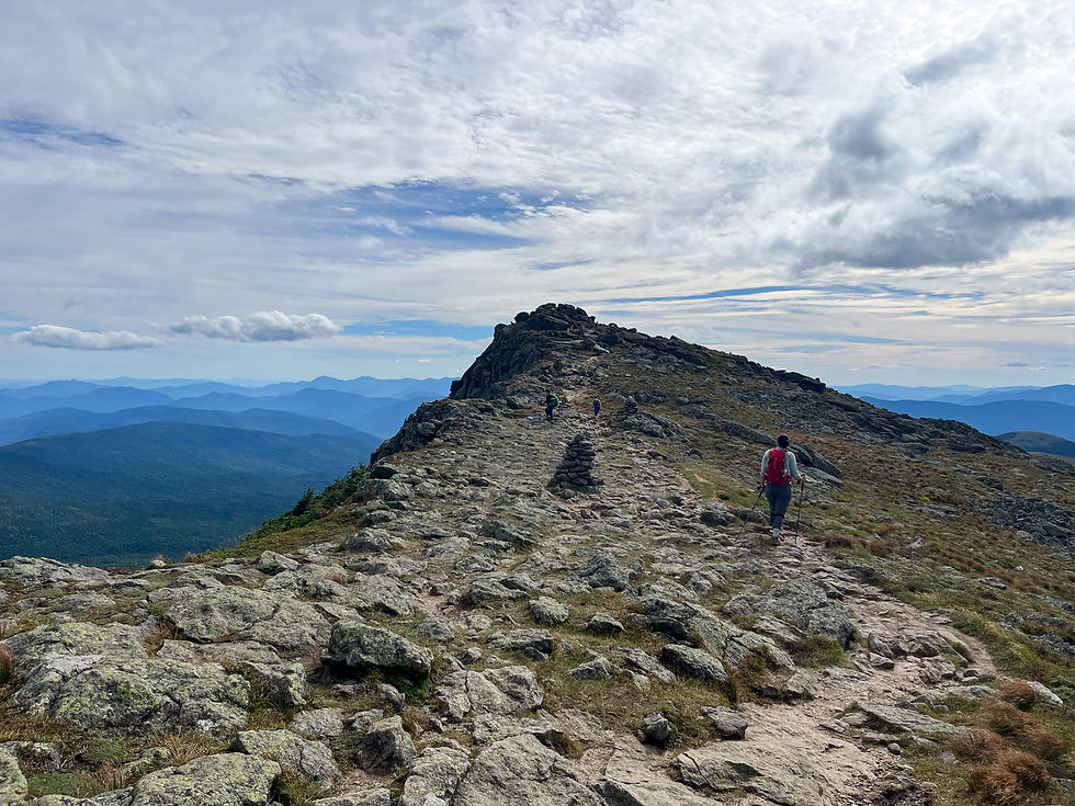
The stretch between Madison and Adams is about a mile, and you'll follow the Star Lake Trail. The signage throughout this traverse is excellent, so don’t stress about losing the trail.

Star Lake was a scenic checkpoint as we continued our climb toward Adams.
I loved this shot looking back at Star Lake and Mt. Madison. Hard to believe we weren’t even 25% done yet. But with views like this, who cares how much farther we have to go?

The climb up Adams felt like the steepest of the entire day. Some sections push beyond a 40% grade!

There’s some scrambling here, too. Blazes and cairns help mark the best path, but you could miss one if you're not paying attention. Luckily, you’re not at risk of walking off a cliff. Just keep heading up and you’ll get there.

That final push to the top...

Mt. Adams—check! My watch showed it had taken us about 3.5 hours to get here. At that pace, we were looking at a 13.5-hour day, finishing after sunset. I held off on pushing the pace. I figured it was still too early to crack the whip.

We got a nice preview of the next two peaks. Time to start digging for that motivation.
#3 Jefferson (5,712ft / 1,741m)

There are a couple of options to descend Adams, but we headed west along Lowe’s Path to connect with the Gulfside Trail. You’ll pass right by the shoulder of John Quincy Adams. It's technically not a 4K due to lack of prominence, but still worth a nod.

The signage is still great here. You’ll start seeing signs for Mount Washington instead of Jefferson. But don’t worry, you’re still headed in the right direction since Washington comes right after Jefferson.

This section dips briefly below treeline. It didn’t offer much shade, but it did offer this gem of a picture of Rahul.

We also passed one epic rock that juts out eastward that makes for a perfect photo spot. Just look at that million-dollar smile on Luke!

Stay alert for signs; eventually you’ll leave the Gulfside Trail for the final push to Jefferson. As with the others, the junctions are obvious.

The approach to Jefferson was steep, though not as punishing as Adams.

And that’s #3 in the books. Can you tell we were getting tired? Only one of us managed to hold up the correct number of summit fingers…
#4 Washington (6,288ft / 1,917m)

Onward to Washington—our halfway peak and the tallest in New Hampshire. It’s over 3 miles from Jefferson and you’ll gain another 1,400 feet, so it’s a grind.

But by now you’re fully above treeline, and those sweeping views help ease the pain.
This is also where you can choose to summit Mount Clay, a sub-peak just off the Gulfside Trail. It looks like it belongs in the Presi Traverse (Clay was a president, after all), but it’s not officially a 4K due to lack of prominence. It only adds ~200 feet of elevation, so it’s not a big detour. However, if you’re conserving energy and strictly focused on the 4Ks, you can bypass it via Gulfside.

The final approach to Washington is tough. The huge boulders are brutal on the knees and tend to shift underfoot. But it’s all worth it, because…

You’ve reached the top of New Hampshire! It’s always a little surreal to arrive at a summit after hours of hiking, only to be surrounded by people who drove or took the cog railway up. Still, we weren’t complaining.

Because it was lunch time. Greasy pizza slices and cold Powerades were just what we needed. By now we’d logged over 7,000 feet of gain and our bodies were feeling it
We lingered longer than we should have, trying to rally our strength. Eventually I had “the talk” with Luke and Rahul. It was 2:00 PM. Halfway done in 7.5 hours. The second half would be faster, but we needed to move. I didn’t mind descending in the dark, but I really wanted to reach that final summit while we still had daylight. They agreed. And just like that, it was time for Part 2.
#5 Monroe (5,384ft / 1,641m)

Leaving Washington requires a little focus. There are several trails leading down from the summit. We followed the Crawford Path toward Lake of the Clouds and Mount Monroe. I was especially grateful that the first part was downhill, because those two slices of pizza were sitting heavy.

That descent from Washington to Monroe might be one of the most painful sections of the day. The large, uneven rocks just destroy your knees. But the reward? Lake of the Clouds in all its glory.

Just past the Lake of the Clouds Hut is the start of the climb to Mount Monroe.

At this point, we were in grind mode—heads down, just powering through.
Luckily, the ascent is short, and we found ourselves nearing the summit in no time.

Fives all around for peak number five. Just three more to go. Can we make it?

From here, we had a great view of the final stretch. I was gaining confidence we could finish with daylight, but we had to keep the momentum.
#6 Eisenhower (4,780ft / 1,460m)
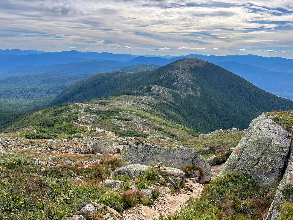
The trail takes on a new personality between Monroe and Eisenhower. As the elevation drops and the peaks shrink, the landscape shifts from bald alpine rock to a mix of hardy vegetation and stone. I found this change in scenery snapped me out of “just survive” mode and helped me appreciate where we were.

Though Eisenhower is over 2 miles from Monroe, it felt like we got there quickly.

Soon enough, we were standing on its broad, flat summit.

Still enough energy in the tank for a group selfie. Six down, two to go!
#7 Pierce (4,310ft / 1,310m)

From Eisenhower to Pierce, the trail dips back below treeline for most of the leg. Instead of wide views, you’re once again surrounded by green forest.

That said, this section has its own charm, like these neatly laid planks guiding the way.

Just before the summit, you pop above the trees one last time.

Lucky number seven! Pierce was a pleasant stop, though its partially wooded summit didn’t offer quite the same epic views. Still, hard not to feel a little pride looking back on how far we’d come.
Pierce is where you decide whether or not to tag Mount Jackson. Continue on to Mizpah Hut, then take the Jackson-Webster Trail to your eighth summit. Or, save Jackson for another day and descend directly via Crawford Path. Either way, whether your car is at AMC Highlands or the Webster-Jackson trailhead, it’s not far from the exit.
#8 Jackson (4,052ft / 1,235m)

Our stubbornness won out. With 90 minutes of daylight left, we pushed on to Jackson. The first section, along the Webster Cliff Trail to Mizpah Hut, included some wooden ladders to navigate steeper terrain.

Soon we reached Mizpah Hut. I poked my head inside and felt a brief pang of envy for the hikers already winding down their day. But we had one more mission. From here, follow the signs for the Webster Cliff Trail toward Mount Jackson.

This section winds through more forest and gradually descends before the final climb.

One spot that stood out was a brief clearing, just enough to glimpse Jackson peeking above the trees. That little visual reminder gave me the final jolt I needed.

Mount Jackson bagged! 12.5 hours after starting, we had summited our eighth and final peak.

Our reward? Lukewarm Capri Suns we’d hauled all day. #summitsuns

We lingered on the summit for a few quiet moments, savoring the accomplishment. But we weren’t done yet.

We still had to drop over 2,000 feet across 2.5 miles to reach the car. This photo of Luke pretty much sums up how we were all feeling: “F**k, I just want to be done with this thing.”
As the light faded behind the trees, we threw on our headlamps and began the slow, rough descent. Exhausted and losing focus, each of us took a few tumbles on unseen roots. There wasn’t much conversation—just quiet headlamp-lit plodding through the dark.
But when we finally reached the car and peeled off our shoes, everything changed. A round of fist bumps, a shared look of pride. We had finished the Presidential Traverse.
SS Reflections
The Presidential Traverse still stands as my most impressive single-day hiking achievement. I’ve never gained more elevation in one go, and even my longest days on the Colorado Trail didn’t ask this much of my body.
Sometimes I think I was so focused on finishing that I didn’t pause enough to fully soak in the beauty of the range. But then I remember what we accomplished—and I can’t help but smile. At the time, I told myself, “Never again.” But now, writing this and reflecting… a little voice in my head whispers, “Maybe. Just maybe.”
Other Helpful Resources
Alpha Guide's detailed post about doing the traverse
This Appalachian Trail website that allows you to reserve some of the huts you could stay at along the Presidential Traverse


