
Osceola and East Osceola: A Classic New Hampshire 4,000 Footer Combo
- Sep 28, 2025
- 4 min read

Mount Osceola is one of the most approachable 4,000-footers in New Hampshire with moderate distance, manageable grade, and rewarding views from the summit. It’s a great choice for newer peakbaggers or anyone chasing foliage hikes in the Whites.
But if you’re looking to turn up the intensity just a notch, continue past Osceola to tag its sister summit: East Osceola. This will add a little cayenne pepper to the outing — with steeper scrambles, rougher terrain, and the infamous Chimney section — making this adventure even more memorable.
Trail Info
Trailhead Name | TRAIL NAME |
Distance | Osceola only: 6.4 miles / 10.3 km (out and back) Osceola + East Osceola: 8.4 miles / 13.5 km (out and back) |
Estimated time | 3-5 hours |
Elevation gain | Osceola only: 2,100 ft / 640 m Osceola + East Osceola: 2,900 ft / 880 m |
Highest point | 4,340 ft / 1,323 m (Osceola) |
Permits / fees | National Forest Fee ($5) |
Parking | Dirt lot |
Toilets? | Yes |
Dog friendly? | Yes |
Know before you go
This is a very popular trail, especially in peak foliage season. Arrive early to secure parking near the trailhead.
East Osceola has no summit view and is mostly targeted by hikers completing the NH 48 list.
The route between the two summits includes a Class 2+ scramble known as The Chimney. It’s short but steep and can be tricky, especially in wet or icy conditions. There is a bypass, but even that feels more technical than your average White Mountains trail.
Other trails nearby
Mount Tecumseh
Distance: 5.2 miles (8.4 km) out and back
Elevation gain: 2,200 ft (670 m) gain
Details: The Tripoli Road approach is just up the road. Also not far away is the Waterville Valley approach
Tripyramids
Distance: 11 miles (17 km) out and back
Elevation gain: 3,000 ft (910 m) gain
Details: A much more challenging loop with steep Class 3 scrambling on the North Slide It's located near Osceola, but a very different beast.
The Trail

The hike starts out gradually, climbing through dense forest.

Most of the trail remains in the trees, but catch it during peak foliage, and you'll get colorful bursts lighting up the trail.

The terrain is mostly steady — a mix of solid packed trail and rocky sections, with a few ledgy spots sprinkled in as you gain elevation.

Occasional openings in the trees offer sneak peeks of the White Mountains, and on a good day, you’ll feel like you’re walking through a fall postcard.

Just before the summit, you’ll hit the trickiest part of the Osceola climb — a stretch of angled slabs that can be a bit dicey when wet or icy.
And then — summit time! While the views aren’t 360°, the large rocky summit provides plenty of space to sprawl out, grab a snack, and take in the landscape. You’ll get northeast-facing views of the Whites...
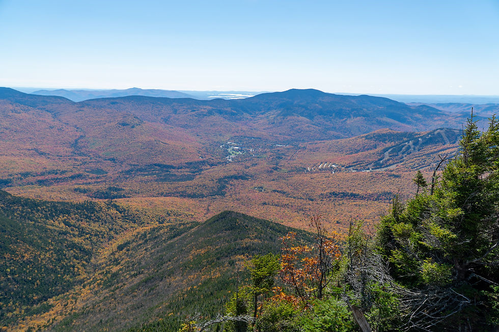
...as well as a look southeast toward Waterville Valley, where you can see the ski trails cutting through the trees.
East Osceola

If you’re only hiking Osceola, this is your turnaround. But if you’re tagging both peaks, continue through the opening in the trees on the opposite side of the summit.

The descent to the East Osceola col will wake you back up after the Osceola summit. It drops around 500 feet, and the terrain gets more rugged and uneven.

Here’s a shot looking toward your destination. It doesn’t look far, but it’s a tough stretch.

The most memorable part of this section is the Chimney, a short Class 2+ scramble that requires hands-and-feet climbing.

From this angle, you can see there are solid handholds and decent footing, but it’s still steep and will trigger a fear of heights if you have one.

There is a bypass trail just to the right (when looking uphill). It’s less steep but still rocky. Many people descend the bypass and then climb back up the Chimney on their return for a better photo or bigger challenge.

After one more push, you’ll reach the summit of East Osceola. It’s marked by a pile of rocks in the woods. Sadly, there's no view at the official summit, but there’s a small clearing nearby that gives you a partial lookout.

But we didn’t linger. After a quick summit photo, we turned back toward Osceola, eager to return to the real views. Two 4,000-footers and a full dose of fall color? That’s a win in my book.
SS Reflections
Mount Osceola was a rare repeat for me. I first summited it just a few weeks after moving to New Hampshire, well before I knew I’d eventually chase all 48 of the state’s 4,000-footers.
So when I realized I’d have to re-summit it just to reach East Osceola — a viewless peak, no less — I wasn’t all that excited. I’ve always viewed repeat hikes through the lens of opportunity cost: what new thing am I giving up to do this again?
But that day in the Whites quickly became one of my favorites. The foliage was unreal, with golden light filtering through the trees and painting the mountains in stunning, reds, yellows, and oranges. And more importantly, I got to watch my hiking partner (someone who’s not a fan of heights) tackle the Chimney with focus and determination.
There’s something powerful about watching someone lean into fear and come out the other side. It reminded me that success on the trail isn’t always about the peakbagging stats. Sometimes it’s about showing up, facing what challenges you, and proving to yourself that you can do it.
Other helpful resources
Two People on an Adventure's post about this combo
4000 Footers writeup about these peaks


