
South Kaibab and Bright Angel Loop: The Grand Canyon "Rim to River to Rim" Hike
- Nov 20, 2023
- 5 min read
Updated: Aug 17, 2025

Hiking from the South Rim to the bottom of the Grand Canyon and back up in a single day? Sure, why not! Nicknamed the “Rim to River to Rim” trail, this South Kaibab to Bright Angel loop is a serious physical challenge. The mileage, elevation change, and potential heat make this a feat of endurance. But for those who prepare and push through, it’s an unforgettable experience. You’ll earn every view—and the bragging rights.
Trail Info
Trailhead Name | South Kaibab to Bright Angel |
Distance | 15.6 miles / 26.7 km (point to point) |
Estimated time | 7+ hours |
Elevation gain | 4,750 ft / 1,450 m |
Highest point | 7,180 ft / 2,190 m (Start of South Kaibab) |
Permits / fees | National Park fee |
Parking | Parking lot D (cannot park at trailhead) |
Toilets? | At trailhead and periodically on trail |
Dog friendly? | No (prohibited) |
Know before you go
You can’t drive to the South Kaibab trailhead. Park at Lot D near the Backcountry Information Center and take the Hikers’ Express Shuttle. I highly recommend arriving early. Spots fill fast, and the next shuttle is an hour later.
This hike can be dangerously hot. Temps at the rim can be deceiving. It gets much warmer 4,000+ feet down at the canyon floor. The NPS does not recommend this as a day hike due to risks of heat exhaustion and dehydration. If you attempt it, bring lots of water and start early.
Alternate routes
Make it a backpacking trip by staying overnight at Bright Angel Campground near the river. You'll dodge the worst heat and get to sleep beside the Colorado River.
Sample South Kaibab as a partial hike. Ooh Aah Point and Skeleton Point are great turnarounds with epic views.
Bright Angel out-and-back is another option. Turn around at the 1.5 or 3-mile resthouses, or go deeper to Havasupai Gardens for a shady, green canyon oasis.
The Trail
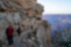
The trail starts out strong. You will follow sweeping switchbacks dropping down from the rim with nonstop canyon views. I got going at 6 a.m. and was surrounded by other early risers. The air was cool, the energy was high, and we were all ready for this endurance test.

Every turn on South Kaibab revealed a new perspective of the canyon. The colors, the shadows, the scale were just unreal.

It was hard not to stop for a photo every few minutes.

About a mile in, you’ll hit Ooh Aah Point. I found this to be of my favorite views of the whole day. It definitely lives up to the name. Just be warned: now you’ll have that Grits song stuck in your head.

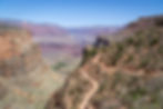
A lot of the descent looks like this—long switchbacks and big views.

There are a few flat-ish sections, but mostly it’s a steady downhill. The trail is a little rocky, but footing was solid.

Just past Skeleton Point, I found another striking view. Peering down, you will see a tightly winding section of switchbacks below. It’s impressive to think about how much effort went into building and maintaining this trail.

About four miles in, you’ll reach the Tip-Off, where South Kaibab intersects the Tonto Trail. This junction is also your bailout option. You can cut across the Tonto Trail to connect to Bright Angel and skip the river section. Bonus: there are toilets here too. Truly a trail that has it all.

After about 2.5 hours of hiking, I got my first glimpse of the Colorado River. Even from a distance, the vivid green color popped against the red canyon rock.

As you descend toward the river, you’ll come to a fork. Going left follows the River Trail to Bright Angel and shaves off some distance and elevation. But if you’ve made it this far and are feeling good, go all the way to the river. It’s worth it.

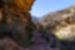
You’ll pass through a short tunnel...

Then cross the suspension bridge over the Colorado. Another surreal moment. The scale of what’s been built out here is astonishing.
After crossing, turn left toward the second bridge to continue on the loop. It’s about a half-mile stroll with another toilet along the way.
Here’s also where you’ll see the junction to North Kaibab. Veering right here takes you toward Bright Angel Campground and Phantom Ranch. I didn’t tack on the extra mile to Phantom, but I’ve heard it’s incredible. No wonder it books out nearly two years in advance.

Crossing bridge #2 gave me one last incredible view of the Colorado. What a place.

After the crossing, hang a right to join the Bright Angel Trail and begin the long climb out. Just after the bridge, I spotted a small beach area. Apparently you can take a quick dip here as it’s protected enough not to get swept downstream. The water’s cold (about 50°F), but probably feels amazing in the heat.

And now, after all that, the hard part begins. The climb back to the rim. It’s a long series of winding switchbacks with little mercy.
Shade becomes precious. You'll sweat. A lot.

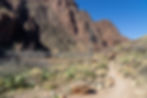
About halfway up is Havasupai Gardens, a lush contrast to the surrounding desert. With picnic tables, a ranger station, a campground, and—of course—toilets, it’s the perfect place for a real break.
Up and up you go. There are two resthouses on the way: one 3 miles from the rim, and another 1.5 miles from the top. These also have water and—you guessed it—more toilets. Turn around every so often to admire the views. It’s wild to think how far you’ve come.

Even in the final miles, Bright Angel delivers. Some of the tunnel cut-throughs carved into the rock were just beautiful.
It did get more crowded near the top. Bright Angel is easier to access, and by now it was the heat of the day. Also, more mules… and mule poop. Watch your step.

After 7.5 hours on trail, I made it back to the rim. If you’ve got any energy left, I recommend walking the flat Rim Trail for a bit. Soak in a few more canyon views and reflect on what you just accomplished. This is a hike you’ll remember.
SS Reflections
I originally planned to backpack the Grand Canyon Rim to Rim, but failed to get a permit. So I reluctantly I pivoted to this day hike. And I’m honestly glad I did.
This was one of the most satisfying day hikes I’ve ever done. From the dramatic switchbacks to the quiet power of the Colorado River to the endless views, every part of this trail delivered. I was exhausted when I reached the top, but I turned around, looked out over the canyon, and thought: “I just did that.”
The most rewarding things in life usually aren’t easy. This hike is proof.
Other Helpful Resources
Follow that nerd's writeup of the journey