
Wheeler Peak: Climbing New Mexico's Highest Summit
- Oct 9, 2025
- 3 min read

Located in the Sangre de Cristo Mountains near Taos, Wheeler Peak is the tallest mountain in New Mexico and it delivers a high alpine adventure with all the trimmings: switchbacks, views, wind, and summit glory. Standing at 13,161 ft / 4,011 m, the altitude alone is enough to test your lungs. But push through it, and you’ll be rewarded with a 360° panorama over the “Land of Enchantment.”
Trail Info
Trailhead Name | Williams Lake Trail |
Distance | 8.6 miles / 13.8 km (out and back) |
Estimated time | 5-7 hours |
Elevation gain | 3,000 ft / 915 m |
Highest point | 13,161 ft / 4,011 m (Wheeler Peak) |
Permits / fees | None |
Parking | Dirt lot at Upper Williams Lake lot |
Toilets? | No |
Dog friendly? | Yes |
Know before you go
This is a high alpine hike. Take the usual precautions: stay hydrated, wear sunscreen, and start early to ensure you're below treeline before any afternoon weather rolls in.
It can get extremely windy above treeline. Bring layers and something to block the wind.
Side Quests
Distance: 4 miles (6.4 km) out and back
Elevation gain: 1,000 ft (300 m) gain
Details: A mellow, shaded route to a beautiful alpine lake. You’ll pass the junction for this en route to Wheeler. It’s a great option if you're short on time or just want a lighter day.
Alternate routes to summit
Distance: 17 miles (27 km) out and back
Elevation gain: 3,500 ft (1,070 m) gain
Details: A less-trafficked but longer option from the east side. Remote and scenic, but tougher logistically.
The Trail

Parking is located at the Upper Williams Lake Lot. From there, walk along the road. The trail runs just to the left side of the road.

Shortly after, the road forks. Take the right fork...

...which leads toward a sign for Williams Lake.
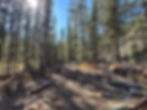
From here, it finally starts to feel like a real trail. It is shaded, forested, and fairly gentle at first.

You’ll come to a junction:
Left: Wheeler Peak (this is your route)
Straight ahead: Side trail to Williams Lake
I skipped the lake on this trip, but it’s a worthy stop if you have time — especially on the way down.

The elevation gain is consistent, but manageable. After this junction, it steepens slightly as you gain altitude.
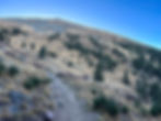
At around 11,500 ft, you’ll break treeline and begin a series of long switchbacks that carry you up to the saddle.

This was my favorite section. The trail opens up and you’re treated to big views of the Sangre de Cristo Range, with scattered alpine peaks stretching into the horizon.

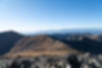
Eventually, you’ll hit the saddle. From here, it’s just 0.25 miles and ~100 ft of elevation to the summit.

But the real challenge on this section was the wind. I’ve dealt with alpine gusts before, but this was something else. I was quite literally walking at an angle, leaning into the wind to avoid getting blown sideways. Still, I pushed on, determined to make the summit.
And with a bit of effort (and a lot of layers) I made it. Wheeler Peak — 13,161 ft — New Mexico high point complete.
Cue the rapid-fire summit shots. I didn’t linger too long, though — the wind chill was no joke, and even bundled up, I was starting to get cold fast.
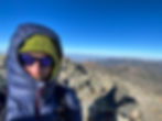
One selfie with the summit marker, a few glances at the surrounding ridges, and it was time to drop elevation fast and warm up.

Next stop? Hopefully some green chile and New Mexican comfort food.
SS Reflections
This hike marked the start of a 3-week Southwest road trip through Arizona, Texas, and New Mexico. It also happened to be my first time ever in New Mexico. What better way to kick it off than by heading straight for the state’s highest point?
At this point in my hiking journey, I’d already climbed 17 Colorado 14ers, so the physical challenge of Wheeler wasn’t overwhelming. But the wind — that was a whole different story. It reminded me that every state has its own version of tough. Colorado might be higher, but Wheeler made its mark in its own way.
And that’s the thing with state high points: it’s not always about altitude — it’s about experience. It’s about discovering what “high” means in a new place, and feeling a little more connected to the landscape because of it.